NAVIGO Web Map is an interactive map website based on the Navigo technology that allows the presentation of maps on company websites.
Thanks to the NAVIGO Web Map, your company website will not only describe your products and services but show the location of your outlets and branches on detailed maps, allow the customers to find the nearest one instantly and plan an access route directly from the provided address. Therefore, the likelihood that customers will use your company’s services increases significantly while the likelihood that they will choose your competitors instead decreases.
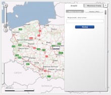
NAVIGO Web Map is a system of physically independent websites communicating online through the SOAP protocol that allows access from any device with a web connection. The NAVIGO Web Map website, based on the Web Services technology, allows displaying maps, fluid changes to the visible area and map scaling, layer visibility management, address and object searches and route planning.
If your company operates as a chain, features a number of outlets and branches, if you want to make it easier for your customers to reach your outlets, then contact us.NAVIGO Web Map is a professional map website, a world-class solution on your websites.
NAVIGO Web Map features include:
- Easy adaptation and implementation
- Quick operation
- Reliability
- Functionality
- Highly aesthetic maps
- Highly flexible and scalable
NAVIGO Web Map can operate as a technological platform for the provision of services to the mass market via the Internet, for GSM (GPRS) operators, GIS solutions for large clients (such as banks, wholesalers, public administration, armed forces, police, crisis management services). High scalability, limited hardware requirements, easy integration with the client’s IT systems are the key features of that technological platform.
Selected website features:
- Map zooming, rescaling and panning.
- Calculation of map distance between two points
- Search for street and house addresses (also non-typical addresses such as 40/42 or 73A) in cities, towns and villages.
- Search for POIs (points of interest) within a given distance from: the given location, start, end, mid-point of a route, the entire route and sorting search results by distance
- Calculation of access routes to a given location (shortest/fastest route) between two (start, end) or more (route mid-points) locations
- Displaying/hiding messages